‘Sabotaged’ tanker in Gulf of Oman leaked oil


A sizeable oil slick developed in waters where tankers were damaged off the United Arab Emirates on 12 May.
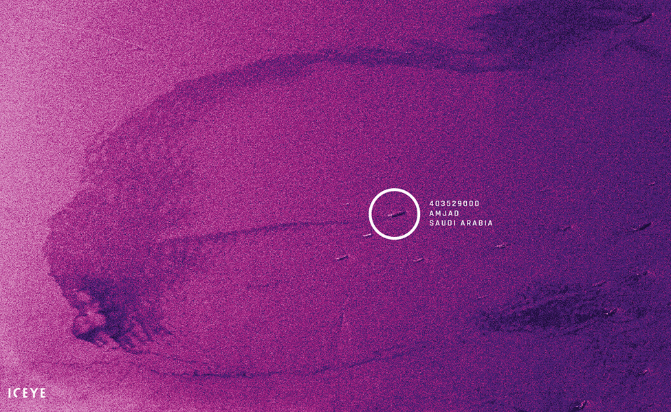
Finnish company Iceye says one of its radar satellites detected a long trail leading from the Saudi-flagged vessel Amjad two days later.
The crude oil tanker and three other ships suffered damage while anchored outside the port of Fujairah.
No-one has yet said they were behind the incidents. Nor is it clear precisely what happened.
US investigators reportedly believe Iran or groups it supports used explosives to damage the ships – but no evidence has emerged to show that Iran was involved.
The radar image on this page was captured by Iceye’s X2 spacecraft on 14 May.
The analysis cannot state how much oil was present on the water, but the interpretation has been validated by Kongsberg Satellite Services, a Norwegian company with expertise in oil slick detection.
“Oil on top of seawater is visible on radar satellite imaging because it changes the way the water surface reflects radio waves,” explained Iceye CEO Rafal Modrzewski.
“Oil forms a layer on top of the seawater. This changes the water’s viscosity, flattening and making the surface smoother. As a result, oil on water appears on the image as a dark patch,” he told BBC News.
The Amjad was reported to be empty of crude so the leak could well be engine fuel.
UAE and Saudi authorities have released few details about what happened on 12 May and an inquiry is under way.
The Reuters news agency reported that damage was inflicted on the Amjad; another Saudi tanker, Al Marzoqah; a UAE-flagged bunker vessel, A Michel; and a Norwegian tanker, Andrea Victory.
The event occurred amid rising tensions in the region.
Fujairah port is located on the east coast of the UAE in the Gulf of Oman and is at the funnel point into the Strait of Hormuz – the main shipping route linking Middle East oil producers with the rest of the world.
At any one time, many tens of ships will be anchored a few nautical miles from the port, either waiting to enter the Strait or stopping off before departing to destinations in Asia, Europe, the Americas and beyond.
Iceye released the X2 image on Thursday as a demonstration of its spacecraft’s capability. The start-up’s satellite design is significantly smaller and cheaper to produce than traditional radar spacecraft.
Iceye already has two suitcase-sized satellites in orbit and plans a large constellation to obtain rapid, repeat imagery of the Earth.
Radar’s great advantage is that it sees the surface of the planet under all circumstances, during the day or night and in all weathers. Radar satellites can therefore see and sense things that will often be invisible to other Earth observers, such as imagers that view the planet at wavelengths of light similar to our eyes.
“Iceye is launching (another) five satellites in 2019. Naturally, the exact timelines can always change depending on launch providers. New satellites are planned to be up in orbit already within a few months,” Mr Modrzewski said.
Both the Fujairah emirate government and the ship owner have been asked for comment.


