‘Molar Berg’: Getting a measure of Antarctica’s big new iceberg
Scientists use satellites to run the rule over the White Continent’s latest mega-berg. …

Media playback is unsupported on your device
European and American satellites have run the rule over the latest monster chunk of ice to break off Antarctica.
Nicknamed “Molar Berg”, the block represents the biggest calving event on the Amery Ice Shelf in 50 years.
Scientists used the EU’s Sentinel-1 mission and the US IceSat-2 spacecraft to get a precise measure of the behemoth’s bulk.
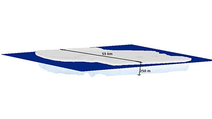
They find Molar Berg to cover an area of 1,573 sq km and to be 248m thick on average (340m thick at its peak).
That gives a whopping volume of 390 cubic km. To put that in terms that might be easier to grasp, it would require the equivalent of close to 100,000 Wembley football stadiums to hold so much ice.
The lines running across Molar Berg are the tracks of the IceSat-2 laser. It senses the elevation of the ice above the sea surface (freeboard). This gives an indication of the amount of ice below the waterline (draft). The thickness of the berg multiplied by the area, calculated from the background Sentinel-1 image, provides a volume.
Molar Berg is so-called because the segment of the Amery shelf immediately next to where it calved looks from space like a “Loose Tooth”. Molar Berg is longer and flatter, akin to a hind tooth – hence the continuation of the dental analogy.
It’s an unofficial name, however.
The US National Ice Center runs the recognised nomenclature for icebergs and it has given the hulking mass the designation D28.
The latest measurements of Molar Berg were compiled by the UK’s Centre for Polar Observation and Modelling (CPOM). It used IceSat-2’s laser altimeter instrument to assess the berg’s vertical dimension, and the synthetic aperture radar on Sentinel-1 to gauge its horizontal extent.
“IceSat-2 measures how much an iceberg sticks out of the water. From this we can calculate its total thickness. And together with Sentinel-1 data, we can also derive the iceberg’s volume,” explained CPOM scientist Anne Braakmann-Folgmann from Leeds University.
Amery is the third largest ice shelf in Antarctica, and is a key drainage channel for the east of the continent.
The shelf is essentially the floating extension of a number of glaciers that flow off the land into the sea. Losing bergs to the ocean is how these ice streams maintain equilibrium, balancing the input of snow upstream.
But researchers will now be watching Amery closely to see how it reacts to the loss of D28/Molar Berg. It could change the stress geometry across the front of the ice shelf, which could in turn influence the behaviour of cracks, and even the stability of Loose Tooth. This segment of ice continues to hang on to Amery even though it was predicted to break away some years ago.
And satellites will also continue to keep a sharp eye on D28/Molar Berg to see where it moves, says Anne Braakmann-Folgmann.
“Icebergs pose a hazard for ships, but if we know how thick they are, we can determine where they can drift in the winds and currents, and where their keel might get stuck on the seafloor.”
Follow Jonathan on Twitter.


