Sentinel for sea-level rise enters testing
The satellite that will maintain the “gold standard” measurement of ocean height is nearly complete. …

 Image copyright Stephane Corvaja/ESA
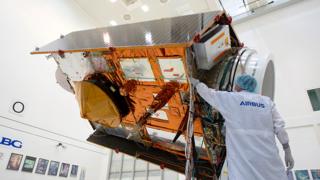
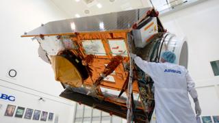
 The next satellite tasked with maintaining the “gold standard” measurement of sea-level rise is about to enter final testing.
Sentinel-6a will pick up from the long-running Jason series of spacecraft when it launches in November 2020.
These missions track the height and shape of Earth’s oceans with microwave altimeters.
Since 1992, the orbiting instruments have observed sea level go up by an average of 3.2mm per year.
This trend is accelerating, however. The most recent five-year period, from 2014 to 2019, has witnessed a 4.8mm/yr increase.
Sentinel-6a marks the first time this hugely important mission series will fly under the badge of the EU’s Copernicus Earth observation programme.
It is still a joint venture between Europe (principally France) and the US, but the Copernicus patronage gives longterm security of financing.
In the past, there was always a little uncertainty over where the funding would come from to initiate the next iteration of spacecraft.
Now, not only is Sentinel-6a entering testing but its follow-on, Sentinel-6b, has all its money in place with construction due to begin in 2021.
Senior space agency and industry officials gathered at the IAGB facility in Ottobrunn, near Munich, Germany, on Friday to celebrate one year to launch.
The IABG company will check over the Sentinel’s systems to ensure they are fit to ride to orbit on a Falcon-9 rocket.
When it eventually gets up there, Sentinel-6a will spend some weeks running alongside the current operational satellite, Jason-3.
This will enable scientists to cross-calibrate their “Poseidon altimeters”.
These instruments are used to map the various “hills” and “valleys” in the ocean surface below.
Understanding the variations in elevation over time has myriad applications, both short term and long term.
Just as air pressure tells meteorologists what is going on in the atmosphere, so ocean height will betray details about the behaviour of water below just the top layers.
The data gives clues to temperature and salinity. When combined with gravity information, it will also indicate current direction and speed.
The oceans store vast amounts of heat from the Sun, and how they move that energy around the globe and interact with the atmosphere are what drive key elements of our weather and climate systems.
A classic example is the El Niño phenomenon. This sees usually cold waters in the eastern central Pacific overtaken every few years by a surge of warm waters from the west. This disrupts weather patterns worldwide, bringing drought to some areas and intense rainfall to others.
Sentinel-6a will act as an early warning system for El Niño by detecting the developing bulge in surface waters associated with the warming.
The spacecraft will be managed on a day-to-day basis by Eumetsat, the intergovernmental organisation tasked with operating Europe’s weather satellites.
It sends the altimeter data to national met agencies to be ingested in the numerical models that produce weather forecasts.
Storm intensity and the onset of heatwaves, to give just two examples, will have telltale signatures in the changes detected in sea-surface height.
Eumetsat also manages another altimeter-equipped Copernicus mission called Sentinel-3.
The key difference is in the orbit flown around the Earth.
Sentinel-6 moves between 66 degrees North and South, while Sentinel-3 goes to 82 degrees.
They are “a system”, says Eumetsat director-general, Alain Ratier.
“Altimeters are narrow-swath and they [look straight down] – and yet the oceans provide great variety across space and time which we have to sample fully. So for this you need several orbits,” he explained.
“Sentinel-6 has a 10-day repeat cycle but the distance between its tracks is relatively large. This means it’s optimised to monitor big features like the Gulf Stream and the Kuroshio Current. Whereas, Sentinel-3 is on a 27-day repeat cycle where the tracks are closer together, which makes it good for seeing the small ocean eddies that are perhaps 15-20km across and move very slowly.”
The latest version of Poseidon altimeter on Sentinel-6 comes with greater precision – so much so that scientists hope it can help tease out even some of the more subtle shifts in climate.
For instance, there’s an expectation that increasing levels of greenhouse gases in the atmosphere will lead to an intensification of tropical trade winds. This should push warm equatorial surface waters westwards.
It’s the sort of detail required to make better predictions about the likely impacts of regional sea-level rise, says Benoit Meyssignac from the French Laboratory of Geophysical Studies and Spatial Oceanography.
“This response from greenhouse gases – we see it in climate models and we’re starting to see in the observations. However, because the uncertainty in observations is about 1.2-1.5mm/yr regionally, we cannot attribute it with confidence. But with Sentinel-6, we expect we will have the necessary precision and accuracy,” he told BBC News.
The European-US partnership at space agency level has become very important in recent years.
Sentinel-2 is a land imager whose data products overlap with America’s Landsat Earth observation programme – deliberately so; their respective imaging instruments were built to complement each other.
It’s teamwork Sandra Cauffmann, the acting director of the Earth Science Division at Nasa, would like to strengthen.
“We are in conversation with the European Space Agency (Esa) and we will be having a workshop in February to consider the potential for partnership in the future architecture of Landsat. It makes sense that Sentinel-2 and Landsat go forward together,” she said.
As well as the European Commission, Esa, Nasa, and Eumetsat – major partners on Sentinel-6 project include the French space agency (Cnes), the US National Oceanic and Atmospheric Administration (NOAA) and Airbus, who built the satellite.
Jonathan.Amos-INTERNET@bbc.co.uk and follow me on Twitter: @BBCAmos


